Best autonomous radiation mapping of a nuclear power plant
The European robotics competition EnRicH was held for the fourth time at the Zwentendorf nuclear power plant in Austria from June 12 to 16, 2023. The goal of the competition is to test the operational capability of rescue robots in a nuclear emergency. The power plant was completed but never put into operation. As a result, it provides an ideal environment for testing the use of rescue robots in the event of a radiation accident under realistic conditions. For this purpose, an accident scenario with a missing worker and several active radiation sources was simulated on the first floor of the power plant.
The task of the mobile robots was to create as autonomously as possible a precise three-dimensional map of the building geometry and a map of the radiation intensity in this environment, as well as to precisely locate the radiation sources. Furthermore, based on radiation measurements, various manipulation tasks were to be performed, e.g. closing valves or operating buttons, as well as searching for a missing worker and transporting him to a safe area.
While in the previous competition two years ago the robots operated in a relatively spacious area with few obstacles and good radio coverage, this time the environment was much more challenging: narrow corridors with a wide variety of obstacles, a three-meter-deep hole that the robots had to avoid, large areas with only poor or no radio communication at all, and in some cases complete darkness. This significantly increased the demands on the robustness of the robots’ autonomy, perception and navigation.
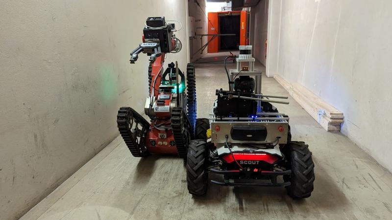
Team Hector from the Department of Simulation, System Optimization and Robotics competed again this year in a cooperation with the German Center for Rescue Robotics (DRZ), of which the TU Darmstadt itself is a founding member. Two cooperating ground robots were used. One was TIM, a mobile ground robot with variable chain drive and precise manipulator arm, which is available to the team as part of the collaborative research project funded by the German Federal Ministry of Education and Research (BMBF) to establish the German Rescue Robotics Center. As part of the KIARA joint project coordinated by the department, the robot is being used to investigate the support of police task forces in acute local danger situations. The other is emergenCITY Scout, a mobile wheel-driven ground robot for rapid exploration of urban areas in crisis scenarios, which was developed as part of the LOEWE center emergenCITY.
Mobile artificial intelligence for disaster scenarios.
Since manual control of rescue robots in complex disaster environments is challenging and error-prone, the team is researching the development of intelligent assistance functions to support operators. This should make operations more effective and safer in the future.
Both robots are equipped with autonomy function modules developed at TU Darmstadt. The sensors installed on the modules are used to enable assistance functions, such as autonomous exploration or approaching a specified waypoint, using new algorithms. For example, complex algorithms have been developed to fuse data from the lidar, inertial measurement system and 360° camera to calculate the robot’s position in real time and generate an accurate three-dimensional model of the environment. Camera data is semantically analyzed directly on the robot to locate the missing worker. The addition of a dosimeter enables the creation of a radiation map and the localization of sources.
From the 3D model, it is determined which areas can be safely navigated and which areas are still unknown. This allows the autonomous exploration method to safely plan paths through the power plant. In manual control, the operators are supported by the real-time generated 3D model of the robot and its environment, e.g. collisions with the environment in confined spaces can be avoided as well as holes in the soil.
The modules also continuously check the quality of the radio link and are equipped with functions that can safely navigate the robot back again even if the radio link is lost for too long. This ensures that the robots are not lost after the radio link is broken.
Cooperative success
In the competition, the two robots were able to explore the environment successfully and efficiently cooperatively, using the autonomy and assistance functions. For example, the fast and agile robot Scout performed an autonomous preliminary reconnaissance with rough localization of radiation sources. The positions were passed on to the second robot TIM, which was able to target the positions and use its moving arm to precisely locate the radiation sources and perform the build-up manipulation tasks.
All data was processed in real time on the robot during the mission, and so the maps and models could be handed in immediately after the mission was completed.
In the event of an emergency, the robots could initiate initial reconnaissance and defensive measures to deal with the disaster, for which rescue forces would otherwise have to expose themselves to high risk. The direct availability of the maps and models provides a detailed picture of the situation and can provide valuable support for further mission planning.
High quality convinced
In the end, the jury was convinced by the high quality and accuracy of the 2D and 3D radiation maps created in the competition, so Team Hector took first place in the radiation mapping categories.
Besides the trophy, the team is happy about the successful competition and exciting data sets. These will be published together with the developed methods in a timely manner so that other research groups and rescue organizations can benefit from the findings.